Welcome to Hemlock and Canadice Lakes!
Barns Businesses Cemeteries Churches Clinton & Sullivan Columns Communities Documents Events Time Line Fairs & Festivals Farm & Garden Hiking Homesteads Lake Cottages Lake Scenes Landscapes Library News Articles Old Maps Old Roads & Bridges Organizations People Photo Gallery Podcasts Railroad Reservoir Schools State Forest Veterans Videos
|
News Article |
|
|
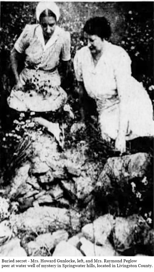
The Mysterious Water Wells of Springwater NY From the Democrat and Chronicle, 21 October 1956 By Arch Merrill. Rediscovered by Donna Walker. 1 Buried secret - Mrs. Howard Gunlocke, left, and Mrs. Raymond Peglow peer at water well of mystery in Springwater hills, located in Livingston County. Thar’s mystery in them thar hills. There is scenic grandeur, too, in those legend-haunted heights east and south of Tabor Corners in the Town of Springwater NY. At one point the hills stretch 1,160 feet above the level of the sea, the highest elevation in Western New York, excluding the Southern Tier. A section of those hills has been known for years as “the Fort,” because of a legendary fortification there. On a high and lonely plateau east of the Peglow Road, among several springs and walled-up holes, is a finely constructed, stone-walled well, some 18 feet deep and covered by a large flat stone. That well is dry and perhaps always has been. At least one of the others has held water in recent years, some are choked with rocks and dirt. Even the oldest residents can’t remember when any of them was used. None of them is close to any present habitation. Who dug them, when and why are questions which have given rise to all kinds of yarns and speculation. The natives call them “the Indian wells,” although the Senecas never had occasion or inclination to dig wells in a land of many lakes and streams. Some connect the wells with the Sullivan Expedition of Revolutionary times, but the colonial army marched well to the north of “the Fort” and there is no record of any detachment ever being in the Springwater hills. About a mile west of the “Indian wells” is another mystery - an ancient, abandoned cemetery in the middle of a field. Of the core of headstones there, only two are marked - and they go back to the 1820s and 30s. The rest are plain field stones, set upright in the ground. I think there is a definite connection between the wells and the burying ground. Both point to a long-vanished settlement in those rugged hills. It happens that the mystery wells are on land owned by Rochester’s public safety commissioner, Kenneth C. Townson. But the commander of the bureau that solves city mysteries is quick to admit that he has no answer to the one on his vast Livingston County farm. For more than 70 years there have been Peglows living on the road that bears their family name. Oldest of the clan is 82-year-old Edward Peglow, whose son, Raymond, now operates the family farm. It adjoins the “Fort Farm,” which Commissioner Townson acquired several years ago from the late Senator James W. Wadsworth. The discovery of the “Indian Wells” goes back to a day in 1929 when Ray Peglow, cutting hay on his land, noted a man with a blueprint, directing six other men wielding picks and shovels on “the Fort Farm.” The man with the blueprint was the late Mark Wright of Springwater and he was uncovering the old wells in the belief that they were of great historical interest. He told the Peglows he hoped to develop the site and pledged them to secrecy about his discovery. Wright died shortly afterward. The Peglows kept the secret for several years. Then came the flood of theories - tales of Indians, a great stone fort, of Sullivan’s solders and settlers using the wells for storage. A few practical folks believe that the wells belonged to a deserted settlement whose people are buried in the lonely graveyard in the field. |
||
|
***
It was Ray Peglow’s wife, Margaret, who guided us on a tour of the “Fort.” She drove across fields directly to the deep dry well with the flat stone above it and then to the deserted cemetery on Ed Thorpe’s land. Carved on one field stone are these words: “Isaac, son of Isaac and Harriet Koons, died Feb. 9, 1828, 3 yrs. and 6 mo.” On a conventional marble headstone, now flat on the ground, is this hard-to-decipher legend: “Polly, wife of Reuben Thompson, aged 32 - 1832.” The other markers clustered about them are unmarked field stones. An “Early History of the Town of Springwater” written in 1887 by Orson Walbridge states that at an unspecified early time, “Lemuel Crocker and Isaac Koons lived at the Fort, so called ... Crocker moved to Michigan. Koons died here.” That’s the only record I could find of a settlement on the hill. The cemetery was abandoned so long ago there is no record of it in county archives. |
||
|
***
A talk with historically minded George Higgins, former Springwater supervisor who lives on the northern edge of the village, shed light on the mystery. Higgins spent his early years around Tabor Corners. He once owned 50 acres near the Fort, which he sold to Commissioner Townson. He knows that neighborhood as well as he knows the big gladioli garden back of his house. He said that from what he had been told by his elders and his own youthful observations, he was certain that at least five houses once stood within a mile radius of the Fort. All left the scene long ago but Higgins remembers exploring their sites and finding heaps of stones that once were house walls, pansy beds and other flowers, all evidences of one time habitation. With a carpenter’s pencil he drew a map on the bottom of a crate soon to hold gladiolus bulbs. It showed the location of each departed home. He buttressed the theory that the graves in the field are those of the people who lived in the several dwellings round-about in the early days and that they dug the wells. |
||
|
***
More than a decade ago, L. Burr Scott, a Wayland town clerk, explored the “Indian Wells.” He was accompanied by Miss Lena Thwing, now of Albany, then Wayland correspondent for the Democrat and Chronicle. It was she who tipped me off to the mystery of the hill country. Scott wrote for me his recollections of his investigation and outlined a theory of his own. At the time of my investigation most of the wells had been filled in with rocks and dirt but were still in evidence. The hole farthest south near a tree, was filled with water. It was 18 feet deep and two feet wide inside. About 20 or 30 feet to the north was the one still preserved as in former times, covered with a flat rock and buried under a pile of stones. I uncovered this and found it to be the same dimensions as the “wet hole”. Thinking it curious that one hole was full of water and all the rest dry, I climbed down into the well-preserved one. The bottom was 18 feet from the flat rock and well stoned up. I carefully took out the bottom stones and replaced them one by one, to try to determine if some artificial method had been used to keep them dry. I could find nothing definite but still like my idea. Scott conjured up this interesting speculation of a frontier settlement on the hill: Perhaps, alone and friendless, these pioneer people gathered at a convenient hilltop found a well for water, dug dry wells and kept them dry by deep ditches filled with gravel to drain off the water, kept some grain and supplies stored in the hole, to enable them to survive if and when attack occurred. |
||
|
***
Perhaps the mystery of the hills will always be a mystery. No matter. Nature has written an enduring glory in that rugged countryside. The four-way view from “the Fort” is grand in any season. Now in October, when the woods wear their coat of many colors, there is a special magic in these hills.
|
||
|
Newspaper articles from FultonHistory.com |